The map below by Jan Jansson was published in 1646 and shows the parishes and villages where our Tregurtha ancestors lived. Research has shown that every Tregurtha can trace their roots back to the western corner of Cornwall, where our oldest forebears rarely ventured further than a few miles, some over many generations. However, as time passed and the world began to be explored, so the Tregurtha name began to spread its branches, eventually putting down roots in the largest continents around the globe, making new beginnings while also keeping the strong reputation of the Tregurtha pedigree alive.
Below the maps is a short historical account relating to each parish village.
The original map is located in the Photo Archives section in the Members Only area.
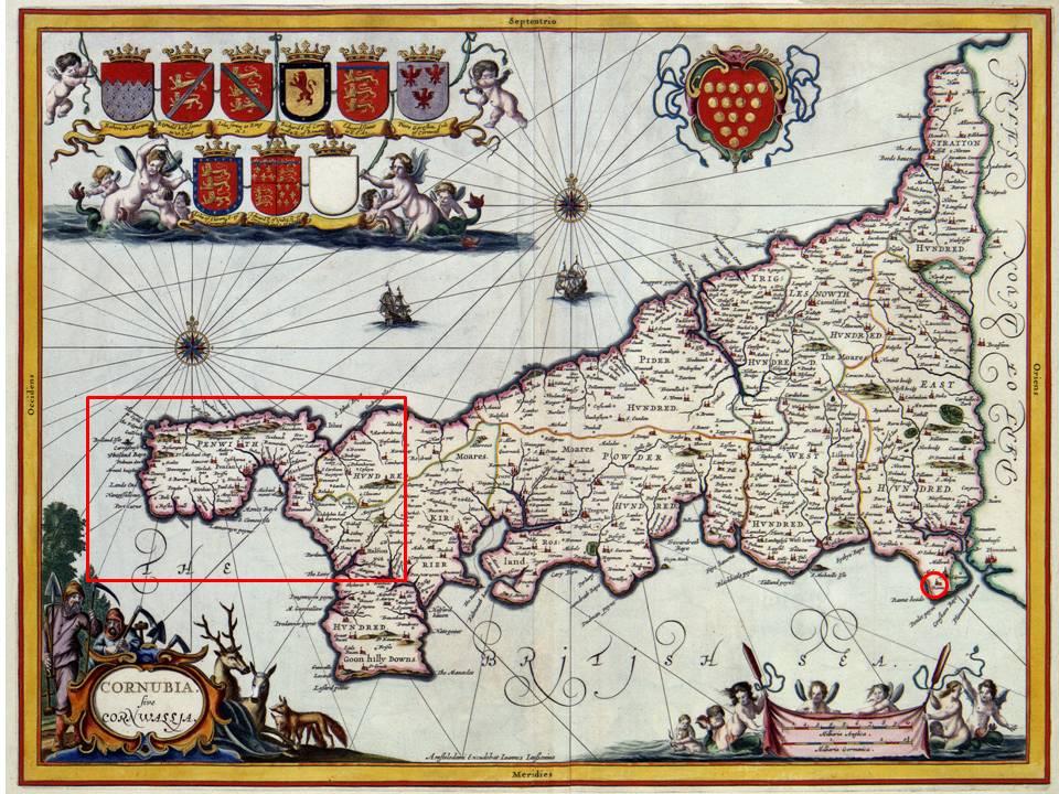
The red square on the left is enlarged below to show the parishes where Tregurthas lived and worked for many generations. The circle to the very right highlights the parish of Rame, the only other known parish in Cornwall where Tregurthas were born and lived. (This map was purchased from The Old Map & Clock Company, located in Sennen Cove, Penzance, Cornwall.)
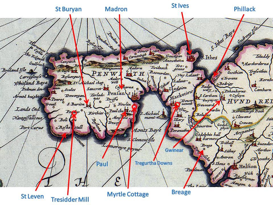
The many parishes where our ancestors lived, as well as a few significant places that you might know.
PARISH INFORMATION
(The following parish information was taken directly from the Genuki website).
BREAGE
Originally called St Breock-in-Kirrier (Kerrier), St Breaca or St Briack, the parish is now just called ‘Breage’ (Cornish: Eglospennbro). It is situated in the Deanery and Hundred of Kirrier (Kerrier), and is bounded on the north by Crowan, on the east by Sithney, on the west by St Hilary and Germoe, and on the south by the sea. The parish of Breage is named after Saint Breage and is either pronounced ‘Braig’, or ‘Breeg’ as it is now more often heard.
Tregoning Hill (596 feet) and Godolphin Hill (495 feet) are in this parish. On the top of the former are the remains of a large Iron Age fort. It appears to have been of great strength and was one of the largest of the kind in Cornwall. The granite on Tregoning was of two types: one was used for ornamental building under the name of Breage stone; the other, abounding in talc, was worked as china clay.
GWINEAR
The parish of Gwinear (Cornish: Sen Gwynnyer), is situated in the Deanery and Hundred of Penwith. To the north is the parish of Gwithian with Camborne also in the north going around to the east. Crowan is to the east going around to the south of Gwinear Parish, with St. Erth and Phillack both lying to the west. This parish lies on high ground south-west of Camborne and is composed of scattered farms and houses. There is archaeological evidence that farming in this area goes back at least to the 2nd century, as a defended farmhouse of that period was discovered in the parish. The village of Rosewarne was once in possession of the Arundells of Lanherne. Gwinear was the son of an Irish pagan king and is reputed to have been slaughtered together with his companions by the Cornish pagan king Theodoric.
Silver and copper mines and related industries were important in the past, but as elsewhere in Cornwall these have now declined. In the 18th and 19th centuries, Rosewarne and Herland mines produced silver, whilst Wheal Alfred and Wheal Relistian produced copper. In those days, the parish was a thriving mining community and one of the first steam engines ever to be built was installed at the Herland mine in 1758. Now the parish has camping and caravan parks and agriculture is the other source of industry.
MADRON
The ancient parish of Madron (or St Madron), (Cornish: Eglosvadern), with Morvah is situated in the Deanery of Penwith, and in the western division of the Hundred of Penwith. Named after an unknown saint, this parish is located north-west of Penzance with pleasant views across Mounts’ Bay and St Michael’s Mount. It was formerly known as Madderne. It comprises two parts: the larger is bounded by Gulval to the north, to the east by the Borough of Penzance and the sea, to the south is Paul and Sancreed and on the west is Morvah. The lesser detached part is bounded on the east, south and west by Gulval and to the north by Zennor. Madron is not mentioned as such in the Domesday Survey of 1086; Madron Church, Tregwainton and Landithy were originally part of the Manor of Roseworthy in Gwinear. However the rest of the parish was taxed under the jurisdiction of the Manor of Alverton.
Its history goes back into the early middle ages. It possesses the mother church of Penzance and the famous holy well of St Madron, where it is claimed many miraculous cures took place. North of Madron is the prehistoric holed stone known as Men-an-Tol, also believed to have had the power of healing. Naked children suffering from rickets were passed through the hole three times in the hope of restoring their health.
PAUL
The parish of Paul, (Cornish: Brewynni), (alias St Paul) is situated in the Deanery and Hundred of Penwith. It was bounded on the north by Madron, on the east by Mount’s Bay, on the south by St Buryan, and on the west by St Buryan and Sancreed. It is located south of the fishing port of Newlyn, and contains the small village of Paul with its fishing port of Mousehole, (pronounced Mowzel), which was originally called Port Ennis.
In the 16th century three Spanish galleys landed a raiding party which left a trail of destruction in the surrounding area. It has been claimed that Dolly Pentreath, who lived in Mousehole in the 18th century , was one of the last people to speak only in the Cornish language. She died in 1778 in her 102nd year.
Many a local lifeboatman has lost his ife in attempting rescues at sea from here. The most recent event was in 1981 when the entire crew of the lifeboat Solomon Browne were lost in going to the aid of the Freighter Union Star.
PHILLACK
The parish of Phillack, (Cornish: Sen Felek), is located to the north of Hayle, and is now one of Nature Conservancy’s Sites of Special Scientific Importance. It was situated in the Deanery and Hundred of Penwith; it is bounded on the north by Gwithian, on the east by Gwinear, on the south St Erth, and on the west by St Ives Bay and Hayle estuary – the latter separates it from Lelant. This is an area of sand dunes stretching from the mouth of the Hayle river at Riviere Towans, northwards to Godrevy Point. It is not mentioned in the Domesday survey of 1086, but the site once appeared to have a Celtic monastery.
RAME
The parish of Rame, (Cornish: Penn an Hordh), is in the extreme south-east of Cornwall, on a peninsula to the west of Plymouth Sound. It is situated in the Deanery of East, and in the southern division of the Hundred of East. It is bounded on the north by the parishes of St Johns and Maker, and on the east, south and west by the sea. The church, situated on high ground, has long served as a navigational aid to mariners. There is also a ruined chapel dedicated to St Michael and traces of ancient defensive works. Polhawn Battery was a strong fortress on the southern cliffs of the parish, effectively commanding Whitsand Bay and the surrounding land approaches. There are four miles of sandy beach on the west coast of the headland, which in the past have witnessed many shipwrecks and are now sprinkled with shacks and bungalows.
ST BURYAN
St Buryan (or Buryan), (Cornish: Eglosveryan), is in the Deanery and Hundred of Penwith. It is in the Land’s End district and is located in the far west of Cornwall. It is bounded on the north by the parishes of Sancreed and St Just, by Sennen and St Leven (to which is closely connected) on the west, Paul to the east, and on the south by the sea. The parish is named after Saint Beriana.
St. Buryan (or Burian) is recorded in the Domesday book of 1086 as Eglosburrie which, in old Cornish, means the church of St. Burian. Beside the Churchtown, the villages are: Bolleit, Boscawen-oon, Boscawen-rose, Penberth Cove, Alsa, Rosemodress, Selna, Treeve, Tregagwith, Trelew, Tregurno, Trevorgans and Trevorrian. The parish lies mainly on granite although, in general, it is fertile and well-cultivated. St Buryan was a Royal Peculiar and came under the Arundells of Lanherne on behalf of the King. The Arundells were Lords of the Manor for something like 39 separate Manors.
In the 18th century Tonkin wrote of St Buryan: This parish is of a large extent, and the land is generally good and lying very warm on the south sea which, with the desires of living quiet, has induced several gentlemen to settle themselves in this remote corner of the Kingdom, where they may liberally entertain all such out of curiosity come to visit Land’s End.
ST IVES
The parish and Borough town of St Ives, (Cornish: Porthia), is situated in the Deanery and Hundred of Penwith. The parish is bounded on the north by the Bristol Channel, on the east by St Ives Bay and Lelant, on the south by Lelant and Towednack, and on the west by Towednack and the sea. The parish is named after St Ja or Ia, who was believed to have been an Irish saint. The story is that she missed the boat carrying her companions to Cornwall and so climbed on a leaf which arrived before them! She is believed to have died at Hayle about the middle of the 5th century.
St. Ives was a small inconsequential town in 1602 according to Carew. By 1700 Tonkin regards it as equal to several other corporations. In the Domesday Survey of 1086 it was taxed with Ludgvan Lees, being the senior manor which encompassed lands in Ludgvan, Lelant, St. Ives and Towednack. Another early manor from the Domesday Survey is Trenwith – legend has it that it was held from King Arthur’s time. The parish was junior to Uny Lelant from at least as early as 1294 until 1869. The current building has parts that date back to the early C15th century (petitioned in 1408, built a little later). The town was known as Pendennis and the principle manor was “Porth Ia” – later “Porthia and Dinas”. The earliest borough charter known was in the time of Charles I but probably existed before that. The hanging of the Mayor (Payne) was in Edward VI reign for being involved in the prayer book rebellion (1549).
The town contains a picturesque fishing port in the far west of Cornwall with special qualities of light that has inspired many artists to live here in the past. The new Tate Gallery (West) houses an exhibition of modern art and has an excellent refreshment room on the top floor overlooking the bay.
ST LEVAN
The parish of St Levan, (Cornish: Sen Selevan), was originally part of the parish of St Buryan and has been closely connected with it. It is situated in the Deanery and Hundred of Penwith. It is bounded on the north by St Buryan, on the east and south by sea, and on the west by Sennen. St Leven takes its name from the patron saint of the church, St Selevan. The parish is ten miles west of Penzance. Porthcurno, on the south coast, was the site of the first cable laid across the Atlantic. Not far from Porthcurno is the Minack Open Air Theatre, built into the cliffs by Rowena Cade in 1932, which has the sea as a backdrop to the stage.
The chief village is Teryn (or Treen). St Levan is also a pleasant village, which in the past relied heavily on shell fishing as source of income. At Porthgwarra (the higher port), a little fishing cove, tunnels are cut through the rock to give access to the sand and ore-weed beach. Penberth Cove is also a fishing place.